Queen Mary's Port (Capitol Landing), Princess Anne's Port (College Landing), 1699-1800
Colonial Williamsburg Foundation Library Research Report Series - 0147
Colonial Williamsburg Foundation Library
Williamsburg, Virginia
1990
QUEEN MARY'S PORT
(Capitol Landing)
PRINCESS ANNE'S PORT
(College Landing)
1699-1800
| I Queen Mary's Port (Capitol Landing) | pp. 1-16 |
| II Princess Anne's Port (College Landing) | pp. 17-22 |
| Illustration #1 | Maps |
| Illustration #2 | Photograph from water color by Cranston |
| Illustration #3 | Numbered lots at Queen Mary's Port with owners' lots numbered from 1-68 |
| Illustration #4 | Lots on Capitol Landing Road to Queen Mary's Port |
| Illustration #5 | Plantations around Queen's Creek and Capitol Landing |
Queen Mary's Port (Capitol Landing)
and
Princess Anne's Port (College Landing)
In 1699 when the Act directing the building of the city of Williamsburg at Middle Plantation was passed by the Assembly of Virginia, two hundred and eighty-three acres, thirty-five poles and a half of land was surveyed for the use of the city. Also, fourteen acres and seventy-one and a quarter poles of land was set apart lying on Queen's Creek "for a Port or Landing Place in Comemoracon of the late Queen Mary of blesed Memory for the sd City of Williams Burgh on the sd Creek wch sd Port or Landing Place shall for ever hereafter be called and knowne by the Name of Queen Marys Port and the aforementioned Road or Way leading thereto shall be caled Queen's Road and ten Acres forty two Poles and a halfe of Land according to the aforesd Draught or Plott shall be and is hereby appointed & set a part for a Road or Way from the sd City of Williamsburgh to the Creek commonly called and knowne by the name of Archers Hope Creek runing into James River wch sd Creek shall for ever hereafter be caled and knowne by the Name of Princess Creek & twenty three Acres thirty seven Poles and a halfe of Land according to the aforesd Draught or Plott lying upon the sd Princess Creek shall be and is hereby appointed and sett a part for a Port or Landing Place for the sd City of Wmsburgh on the sd Creek wch sd Port or Landing Place in Honour of her Royall Highness the Princiss Ann of Denmark shall be called and known by the Name of Princiss Ann Port for ever hereafter and the aforementioned Road or Way leading thereto shall be caled Princes Road…" (Acts of the Virginia Assembly 1662-1702, pp. 399-401, Act XIV; copy in A Brief & True Report concerning Williamsburg in Virginia, by Rutherfoord Goodwin.)
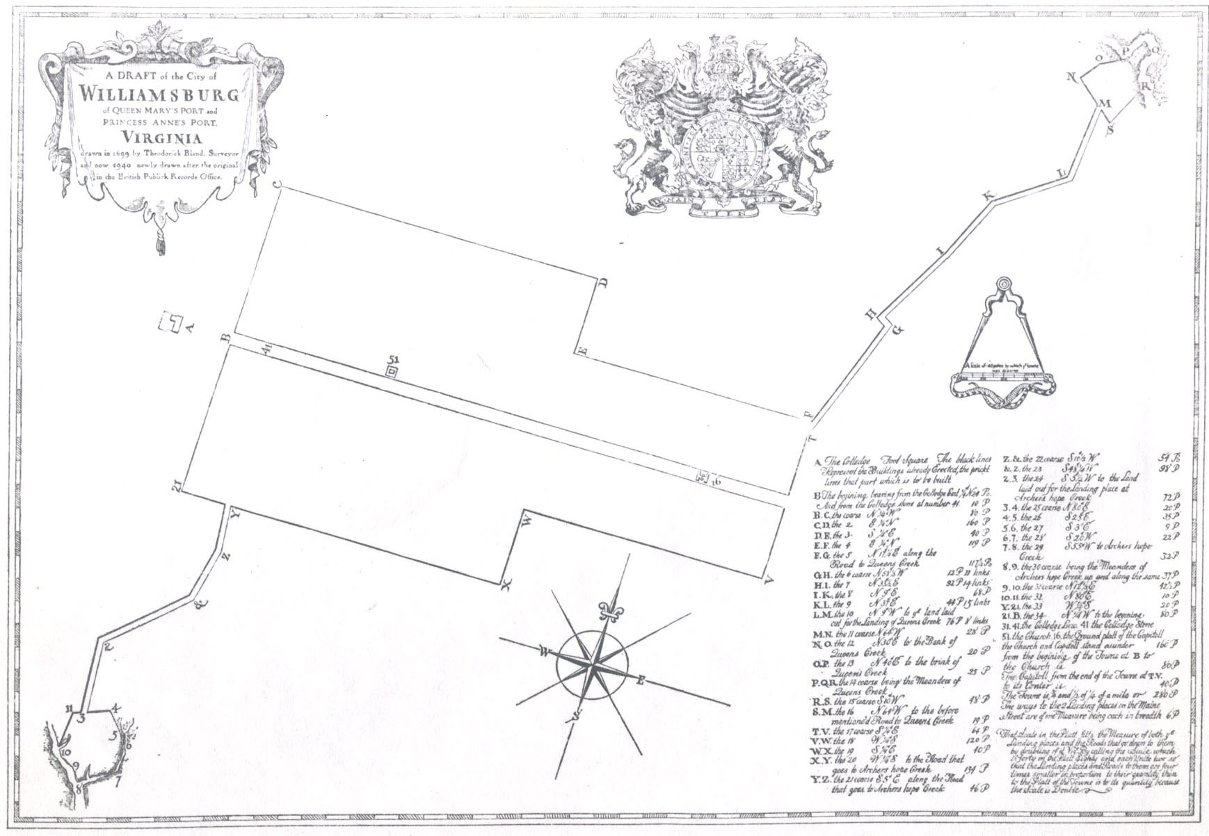
The survey was made by Theoderick Bland in 1699. On this survey Queen Mary's Port and Princess Anne's Port are clearly defined with roads leading from the immediate confines of the city thereto. (See: copy of Bland's Map, Illustration #1, Appendix.)
York County Records (M-1-6)2
Orders, Wills 1709-1716
p 3021713 Feb. 15th
"… two Publick Storehouses to be built at Queen's Creek town Land upon the Land set apart for the building and erecting of the City [of] Williamsburgh the Court having Set a yearly rent on the said hou[se]
These two landings, one a mile northeast of the city; the other a mile southwest, were located on creeks which were navigable in high tide; and provided a convenient port for merchants to ship their goods out or receive merchandise by incoming ships.
Hugh Jones in The Present State of Virginia (1724) refers to the "good Landings" made by early settlers at the heads of the two creeks: one running into the James; the other into York — each about a mile from Williamsburg.
In 1717 the records of York County indicate that the bridge road to Queen's Creek was ordered repaired. (See: Ibid., Orders, Wills, Book 15, p. 181.) Also, in 1717 a petition from the free-holders and inhabitants of the upper precincts of Bruton Parish stated that "convenient roads may be made to and from the bridge lately erected over Queens Creek — the report of John Bates, Surveyor (in these words — We the subscribers have met viewed and laid out the road as convenient as we can to the said bridge with the least damage we could to the proprietors of the lands) — is admitted to record and accordingly ordered that the said Surveyor with the usual assistance clear the roads laid out pursuant to the report and keep the same constantly in repair." (Ibid., Orders, Wills, Book 15, p. 197.) This, probably, was the first bridge erected over Queen's Creek and indicates that there was a need for a bridge.
Waterways to Williamsburg were described in History of the British Plantations in America, by William Keith, published in London, 1738:
There are many small Streams and Branches, which in the Course of these large Rivers fall into them on both Sides, and contribute to make this Country vastly commodious for Traffick, as well as exceedingly pleasant to the Inhabitants: But there are two very remarkable Inlets of Water, or Creeks, navigable with the Tide by any kind of Shallop or flat-bottom'd Boat: The one enters 3 from James River, and stretches North across the Land about five Miles, to a good Landing-place; the other in like manner runs South from York River up into the Land: So that there is a Space only of one Mile between the Landings of these two Creeks, which being a dry gravelly wholesome Soil, was formerly an Indian Settlement, and is now become the chief Seat of Government in Virginia, called Williamsburgh; which by means of the said two Creeks, commands the Navigation both of James and York Rivers; For it was observed, that James Town, and every other settlement on River Side, where the Water was brackish, produced Slow intermitting Fevers and Agues, whereas the above Situation of the Town of Williamsburgh, being perfectly dry, and removed at some Distance from that Nuisance, is found to be very healthy, and free from any such Inconvenience.(Ibid., p. 55-56.)
After the capital was moved from Jamestown to Williamsburg, in 1699, the landings increased in population as the city grew. This growth was occasioned by the increase in trade and the need for greater facilities for handling such. Tradesmen interested in shipping, craftsmen and inn keepers, began to buy lots at Capitol Landing. A ferry came into use about this time.1 One of the early records (1715) shows that a "Lycense to keep a ferry from Queen Mary's Port, Williamsburgh, to Clay Bank in Gloucester" was granted to Giles Moody who also kept a tavern at the port. (York County Records, Orders, Wills, Book 14, p. 417.)
A petition for a "Bridge over Queens Creek" in 1716, York County, gave the location as near the mill and dam of Major John Custis:
On Ye petition of W. Timson, W. Jackson and sundry others, ye inhabitants of Bruton Parish, Setting forth ye Road to be dangerous and inconvenient for Carts and horses by reason of ye Mill and dam belonging to Majr John Custis being ruined by ye late violent Rains, and ye said Custis refusing to rebuild or repair ye said Mill or Dam to ye great inconveniency of ye inhabitants going to their Parish Church or Court, Wherefore, it is ordered that W. Timson and James Burwell, Gent, inquire into ye Charge of building a Bridge Over Queens Creek at Wmsburgh Landing & ye most likely & proper Means to defray ye same & make report to ye next Court."York County Records, Deeds and Orders, Book 15, p. 8.)4
A later order of November, 1724, indicates that "Upon the consideration of the petition of sundry inhabitants of Williamsburgh, and ye upper precincts of this county, for repairing a certain bridge over Queen's Creek, it is adjudged that it ought to be a County charge and that the same be repaired accordingly.(Ibid., Orders, Wills, Book 15, p. 309.) (Further orders concerning the Queen's Creek Bridge will appear chronologically in the report.)
As more vessels appeared at the Landings, loaded with European and East Indian goods, smaller boats as barges, sloops and flats, owned by the plantation owners up and down the James and York Rivers, docked to pick up the merchandise "newly arrived." There was a need for warehouses1 for storing goods or tobacco awaiting the arrival of outgoing ships; ordinaries to house and feed the various types of people brought by business; and shops for men skilled in carpentry and repair work. These buildings were placed on the lots at the Ports or Landings according to the Act of 1699 (referred to above) which provided that "the Lots at the aforementioned Ports or Landings shall be proportioned at the Discretion of the Directors hereafter mentioned, provided that each Lott shall not exceed sixty Foot square which said Lott shall be disposed of in Manner aforesaid and the Produce thereof to be accounted for by the said Feofees or Trustees in Manner as is before expressed any Thing in this Act to the Contrary in any Wise notwithstanding Provided also — that a sufficient Quantity of Land at each Port or Landing Place shall be left in comon at the Discretion of the Directors hereafter appointed… " (See: copy of Act of 1699, A Brief & True Report concerning Williamsburg in Virginia, by Rutherfoord Goodwin.)
5Among the early lot owners at Capitol Landing was Giles Moody, previously cited in the report. In May 1717, the trustees granted unto Moody: "Four certain lots of ground at Queen Mary's Port in ye said city of Williamsburg, designed in the plat of the said city by these figures 22, 23, 24 and 25…"1 (York County Records, Deeds, Bonds, III, pp. 214-215.)
Previous to the acquisition of lots, Moody had been operating a ferry from Queen Mary's Port to Clay Bank in Gloucester. (Ibid., Orders, Wills, p. 417: May 16, 1715.) In June 1718, Moody was granted a license with Philip Moody to keep an ordinary "at his now dwelling house at the Capitol Landing." The yearly fee was "10,000 Pounds of tobacco … we bind ourselves … jointly."(Ibid., Orders, Wills, Book 15, p. 288.) The usual condition in operating ordinaries in Williamsburg was observed by Moody at the Capitol Landing: "… If therefore the said Giles Moody doth constantly find and provide in his said ordinary good wholesome and cleanly lodging and diet for travellers and stabbleage, fodder and provender and pasturage for their horses…and shall not suffer or permit any unlawful gaming in his house nor on the Sabbath day suffer any person to tipple or drink more than is necessary, then this obligation to be void or else remain in full force and virtue."(Ibid.) Records indicate that Giles Moody operated the ferry and the ordinary until his death2 in 1729, whereupon his widow, Mary Moody, kept the ferry as late as 1732.3 (Ibid., Orders, Wills, Book 15, p. 461; Book 16, pp. 178, 402; Book 17 [page not given].)
A court for York County on November 24, 1740 ordered payments for bridge repairs:6(York County Records, Wills, Inventories No. 18, 1732-1740)
To the Honble John Custis Esqr for Mending the Capitol Landg bridge 1000 lb toba To Major John Buckner for the bridge 800 lb toba
Mary Davis kept an ordinary in 1718 "at her now dwelling house at the Capitol Landing." (Ibid., p. 266.) Her husband, John Davis, had held lots #1 and #2 at Queen Mary's Port, (Ibid., Deeds, Bonds, III, pp. 265-266.)
In 1728 another ordinary called, "The Swan," was operated at Queen Mary's Port by Martha Drewit, widow of Jonathan Drewit. The number of the lot was designated as "7" and had been granted to Francis Sharp in 1714. from Sharp it was conveyed to Samuel Cobbs. (Ibid., III, pp. 31; 512.)
In 1723 John Davis, son of Mary and John Davis, applied "to keep an ordinary at his now dwelling at Queen Mary's Port for a year." (Ibid., Orders, Bonds, Book 16, p. 206.)
Within the first half of the century, lots at Capitol Landing were owned by bricklayers, carpenters, tailors, ordinary keepers, silversmiths, merchants, skippers and planters. Nearby, on the road between the Landing and Williamsburg, was a carriage maker's shop, free school and an oyster house with dwelling houses to provide homes. (See: York County Records, Research Department, filed under "Queen Mary's Port.")
A description of a dwelling house at Capitol Landing in this period is given below:
To be Lett or Sold, at the Capitol Landing,
A House, 40 Feet long, and 20 Feet wide, having a Porch, and Brick Chimneys with Fire-Places above and below, a Brick Cellar from End to End, Part whereof is a Kitchen; together with a Parcel of Lots, belonging to Mr. William Mayo, of Goochland County; who has appointed Mr. William Prentis, and Mr. Richard Booker, to act in his Behalf.(Virginia Gazette, Parks, ed., April 29, 1737.)
In 1740 the bridge over Capitol Landing was in need of repair. A committee was appointed by the court to view and give their report:
Capitol Landing Bridge.7
Ordered that Thos. Cobbs, John Blair, Geo. Gilmer, and Ellyson Armistead Gent, or any three of them do meet and go to the Capitol Landing bridge and view the same and make report of their opinions to the next court whether the said bridge can be repaired or not, and if it can be repaired for what consideration.(York County Records, Wills, Inventories, Book 18, p. 601, May 19, 1740.)
It was ordered that a new bridge be built: In 1742 Arthur Dickeson was employed to do the work:
Bridge at Capitol Landing. Sept. 20, 1742.
Whereas Arthur Dickeson was employed to build a bridge at the Capitol Landing over Queens Creek according to a certain agreement for and in consideration of the sum of 50 lbs. current money to be paid to him by this county at finishing the same, and it being represented to this Court that the said Bridge is not done and finished according to the agreement aforementioned. The said Arthur Dickeson this day in his proper person came before the Court and did agree to keep the said Bridge in good repair at his own proper cost and charge for the space of 12 years from the first day of May last, whereupon the Court agreed and accordingly ordered upon his entry into bond (with security in the penalty of one hundred pounds current money) to perform the same that the aforesaid sum of 50 pounds be directly paid him and moreover if the said bridge shall continue strong and sufficient a longer time than 12 years as aforesaid. Arthur Dickeson is to be paid for the same by this County at the rate of four pounds three shillings and four pence per annum.
Wills, Inv., Book 19, p. 126.)
The following month Dickeson and others filed an agreement with Thomas Nelson, Commissioner of the Peace, relating to the contract for the bridge:
October 5, 1742.
Dickeson, Arthur
Cosby, John of York County
Cosby James
agreement with
Nelson, Thomas, Gent. Comm. of Peace.
Consideration: 150 £.… Whereas the said Arthur Dickeson was employ1d to build a bridge at the Capitol Landing over Queens Creek and the said bridge is not finish'd according to the agreement foremention'd the said Arthur Dickeson agreed to keep the said bridge in good repair at his own proper cost and charge for the Space of Twelve Years from the first day of May last whereupon the Court agreed and accordingly order'd, upon his entering into bond to pay the same that the sum of Fifty pounds be directly paid him and moreover if the said Bridge shall continue strong and sufficient a longer time than Twelve Years as aforesd. the said Arthur Dickeson is to be paid for the same at the rate of 4£ 3s. 4d. per annum.
(York County Records, Deeds V, p. 38.)
From evidence which follows one sees that the bridge did not last twelve years "strong and sufficient," for the bridge was ordered rebuilt in 8 1754, and Christopher Ford was the undertaker:
December 9, 1754.
BRIDGE OVER QUEENS CREEK.
Ford, Christopher
Moody, Matthew
to
Gilmer, George
Prentis, John
Waller, Benjamin
Everard, Thomas
Consideration: 140 Pounds for the use of the Justices of the County of York.The condition of the above obligation is such…in pursuance of an order of the Court of said County of York, bearing date 21st day of October, last past have agreed with the above bound Christopher Ford to rebuild the Bridge over Queens Creek at the place where the old bridge now stands for the consideration of 69 pounds, 10 shillings to be paid him by the said County at the finishing of the said Bridge on the last day of June next which bridge the said Christopher Ford hath agreed to build… [book torn] that is to say 100 feet long and [book torn] of white oak, hewed free from sap. The mud sills 25 feet long 16 inches by 12 and the rest of the frame to be 12 inches square or 14 inches by 10 each Peir to have 3 posts and two outside braces, the arches to be 10 feet wide and to be 10 feet high (in the middle of the Bridge) from the top of the mud sills to the under part of the bearers or sleepers, 5 bearers or sleepers over every arch to be covered with white oak plank, sawed 2 ½ inches thick without sap, every plank to be Pin'd with two pins in each end and two in the middle with good seasoned Pins. The rails to be 4 feet high, two rails on each side the whole length of the bridge, which is to be done and finished in a workmanlike manner and to be kept and left in good and sufficient repair by the said Ford at the term of 10 years …
(York County Records, Deeds, VI, p. 23.)
In July 1756 after the bridge was completed, the same named committee contracted with Alexander Finnie and Matthew Moody to build a causeway near the bridge:
… in pursuance of an order of the court of the County of York bearing date the 17th day of May last past have agreed with the above bound Alexander Finnie to erect and make a causeway from the foot of the Bridge over Queens Creek thro the Marsh to the main or high land next the Public Warehouse for the sum of seventy five pounds current money to be paid him by the justices of the County of York within twelve months from the date hereof. The said causeway to be 12 ft. wide at the Top to be raised as high as the foot of the aforesaid bridge and on a level from the said bridge to the main or high land aforesaid, to be well turfed on each side and kept in good repair by the said Alexander Finnie for the term 9 of five years and to be finished on or before the 1st day of October next…(Ibid., no page number given.)
Seventeen years later, it seemed necessary to build a bridge over Queen's Creek at Capitol Landing at a new location.
To be LET, to the lowest Bidder, THE BUILDING of a BRIDGE over Queen's Creek, near the Capitol Landing. Those Persons who choose to undertake the Work, are desired to meet the Subscribers, on Thursday the 2d. Day of September next, at the House of Mr. Matthew Moody, Senior, near the said Landing.
JOHN BLAIR
WILLIAM GRAVES
JOHN DIXON.WILLIAMSBURG
(Virginia Gazette, Purdie & Dixon, eds.,)
August 10 [12], l773.
In October l774 the Williamsburg Masons laid the corner stone of the new stone bridge:
October 6, l774
Yesterday the Lodge of Free and Accepted Masons of this City went in Procession, in the proper Insignia of their Order, to the Capitol Landing, and laid the Foundation Stone of the new Stone Bridge now building over Queen's Creek under which was a Plate with the following Inscription: REGE GEORGIO TERTIO, COMITE DUNMORE PRAEFECTO,
(Virginia Gazette, Purdie & Dixon, eds.)
PEYTON RANDOLPH LATOMORUM
PRAESIDE SUPREMO
JOHANNE BLAIR PRAESIDE
ANNO LUCIS
5774. After the proper and usual Libation, they repaired to the House of Mr. Matthew Moody, Junior (a Brother) and spent the Afternoon in Mirth and good Humour.
The Minutes of the Williamsburg Lodge of Masons for October 5, l774, gave this record of the meeting held at Capitol Landing:
…
The design of this Meeting being to lay the Foundation Stone of the Stone Bridge to be Built at the Capitol Landing — the Lodge accordingly Repaired thereto and after the usual Libations & having placed a Medal under the Corner Stone and laid the same in due form closed the Lodge. The inscription 10 of which Medal is as follows. GEORGIO TERTIO REGE
COMITE DUNMORE PRAEFECTO
PEYTON RANDOLPH LATOMORUM PRAESIDE SUPREMO
JOHANNE BLAIR PRPSIDE— A.L. 5774.
John Dixon Secy Pro: Temp.(Minute Book Williamsburg Lodge of Masons 1774-1779, p. 15, Photostat copy, Research Department.)
By May 1775 work had begun on the new bridge over Queen's Creek. The old bridge was still in use at this time:
(York County Records, Orders, Book 4, 1774-84, p. 87.)[May 15, 1775]
Ordered that John Dixon and Joseph Hornsby Gents cause the Old Bridge over Queens Creek to be repaired until the New Bridge is finished and that they so View the condition of both the Bridges and report the same to the Court.
After the new bridge was completed, it was necessary to make the creek navigable by turning the stream somewhat:
[March 17, 1777]
[Ordered] that Dudley Digges John Blair David Jameson Esqrs William Graves and John Tazewell Gents or any three of them are by the Court appointed to agree with some Person to make the Creek Navigable through the bridge lately erected by Lord Dunmore at the Capitol Landing and to stop up the said Creek where the old bridge stands.
(Ibid., p. 137.)
The Virginia Gazette on March 28, 1777 carried this notice from the committee asking for bids on the project:
11March 28, 1777
Pursuant to an Order of York County Court, appointing us to agree with some Person to make the Creek Navigable through the Stone Bridge lately erected at the Capitol Landing, and to stop up the said Creek where the old Bridge now stands, we give this public Notice, that we Shall Proceed to let the said work to the lowest Bidder, on Tuesday the 15th of next Month, at 3 o'clock in the Afternoon, at the Capitol Landing.
Dudley Digges
Virginia Gazette, Dixon & Hunter, eds.)
John Blair
David Jameson
William Graves
John Tazewell
In September 1777 the sheriff of York County was ordered to pay one hundred and fifty pounds to Lord Dunmore for building a stone bridge over Queen's Creek at Capitol Landing:
STONE BRIDGE AT QUEEN'S CREEK — York County Records, 19 September, 1777.
Ordered, that the sheriff pay the balance of the last county levy to David Jameson, Gent;, and that he, the said Jameson, pay to his Excellency, Lord Dunmore, one hundred and fifty pounds for building a stone bridge over Queen's Creek at Capitol Landing.
(York County Records, Orders, Book 4, p. 157. )
Evidently, the old bridge was used after the new bridge was completed. An order from the court in October, 1778, directed "Beverley Dickson and Benjamin Powell Gents … to agree with some Person to repair the old Bridge over Queens Creek near the Capitol Landing."(York County Records, Orders, Book 4, p. 178.)
By April 1780 a plan was on foot to build a canal for the passage of the water through the new bridge:
[April 17, 1780.]
William Graves Benjamin Powell and Humphrey Harwood Gents are by the Court appointed to agree with some Person or Persons to make a Canal for the passage of the Water through the New Stone bridge lately erected near the Capitol Landing at the Expence of the County.
(Ibid., p. 261.)
A petition filed among the Loose Papers at York County Court House marked "1786" follows the wishes of "divers inhabitants of York County resident in the upper part thereof… ";
That the stone bridge over Queen's Creek at the Capitol Landing hath now almost become impassable so that your petitioners who formerly used that road are under the necessity of going around by Mr Beale's old mill with their carts, etc. or suffer their communication with Williamsburg to be entirely cut off. They further Shew that the road over Capitol Landing had been established and continued as a public Road for upwards of 100 years: that many of your petitioners had purchased their lands on the North side of Queen's Creek in the expectation of enjoying this convenience; that the distance which they will be obliged to travel if this Bridge 12 is not repaired and the road continued before they can communicate with Williamsburg will be to many of them double that which they have lately been obliged to go, and to all very inconvenient. That this is the only bridge in the upper part of the county which is supported at the public expense, and the quota of county levies paid by your petitioners, will, they hope at least, intitle them to the continuance of this convenience, they humbly pray, therefore, that your Worshipfuls will be pleased to direct the Bridge to be rebuilt, or a new wooden one erected in its place.
Signed:
Henry Tazewell William Finnie William Meade Sarah Timson James Hill, Jr. Thad Bright Jackson Saunders James Hewes Wm. Eaton Sarah Vallentine Ralph Graves John Travis Shaddy Kerby H. Graves Sam'l Crawley Richard Booker George Carter John Briant Samuel Beale.
This petition, one would think, applied to the new stone bridge erected ca 1775. However, the petition was in a box marked 1786 at the court archives. It would seem that a stone bridge would not be in need of repair from 1775 to 1786, if properly constructed.
A linen factory known as the "Williamsburg Manufactory," was started by May 16, 1777 "within a few steps of the Capitol Landing extremely convenient to the counties of York and Gloucester, and to the Eastern Shore, from whence any thing may be easily conveyed by water." The manager, John Crawford, noted that "We purpose to purchase rough Materials for Manufacturing, and when wrought up to vend the same … " (Virginia Gazette, Dixon & Hunter, eds. ) In August 1777 Crawford advertised that "continual Demands on us for dressed Hemp" had made it necessary to "have a Mill now erecting, and hope shortly to be able to accommodate our Customers…" (Ibid., August 15.)1
13Somewhat earlier (ca. 1756-7) a petition that a workhouse "where the Poor might be more cheaply maintained, and usefully employed [be had] … and praying, that an Act may pass to empower them to compel the Poor of their Parish, to dwell and work in the said House, under such Regulations and Restrictions, as this House shall direct…" (Journal of the House of Burgesses, 1752-55; 1756-58, p. 260.) The petition also stated "That there is a House belonging to the Parish, at the Capitol Landing, which might easily be converted into a Workhouse."(Ibid.) Evidently, the petition was granted as the Rochambeau Map of Williamsburg and surrounding area (1781), show the Workhouse located across the creek form Capitol Landing on the north.1
Other commercial activities at and around Capitol Landing were the public warehouses and the private warehouses necessary to store the tobacco of planters prior to exporting; also used as repositories for goods imported on call. The usual rent for a warehouse was ten pounds per year. In 1742 Henry Hacker petitioned the Assembly as "Proprietor of the Public Warehouses at the Capitol Landing [for] an additional Rent for the said Warehouses"(Journal of the House of Burgesses of Virginia 1742-47; 1748-49, p. 29.)
On the road between Williamsburg and the Capitol Landing was located the tan works "late the Property of Mr. William Pearson, deceased, with the Dwelling-house and all convenient outhouses both for a Family and the Business, and several Acres of Ground under a good Enclosure, also four negro men Tanners and Curriers, two Shoemakers, a Carpenter, and two Negro Women, one a good Cook, the other a Spinner…"(Virginia Gazette, Dixon & Hunter, eds., March 7, 1777.)
In June 1777, R. Campbell Thomson2 who had been "for many years over-seer of BUCKRAM and GLUE manufactory in Ireland, hereby informs the managers of 14 the Williamsburg manufacturing society, that as the expense of erecting such a work will be but small the factory being convenient to a tan yard, that those useful articles may be made as cheap as they have ever been imported. If such a scheme should be adopted by the society, the subscriber will spare no trouble to instruct any one of their servants." (Virginia Gazette, Purdie, ed., June 12, 1777.) Records do not indicate whether this scheme for the buckram and glue industry worked out or not.
MAPS:
The writer has found only two eighteenth-century maps of Williamsburg and outlying area which shows the Capitol Landing on Queens Creek. One is known as Berthier's Map of Williamsburg (1781); the other is Rochambeau's Map {1781). Photostats of these are in the Research Department.
PLANTATIONS:
Near the Capitol Landing were several plantations of note. One plantation on both sides of the main road leading from Williamsburg to Queen Mary's Port belonging to John Lidderdale, merchant, in 1742. It was bounded by Mattey's schoolhouse and near the land of the late Mann Page, John Hubbard and John Custis. This Plantation was conveyed to John Baskerville, bricklayer. (See: York County Records, Deeds, Book 5, pp. 44-45.)
Perhaps the best known plantation lands in this area belonged to John Custis, father-in-law of Martha Custis, who later married George Washington. Custis came into this valuable plantation via marriage to Frances Parke, daughter of Colonel Daniel Parke of Queen's Creek. From the Diaries of William Byrd and other sources, one sees that Custis livedowned at Queen's Creek plantation between 1714-1749 (year of his death) though Custis also held a town place in Williamsburg known as "Custis Square." (See: Custis Square House History, Research Department.) William Byrd whose wife was the daughter of Daniel Parke, and sister to Mrs. Custis, visited the Custis home on Queen's Creek. The Diaries are full of these visits and the problems encountered in settling the
15
estate of Daniel Parke, his father-in-law. Daniel Parke Custis inherited the Queen Creek lands via his father, John Custis, holding them until his death in 1757 whereupon John Parke Custis as heir became owner. The property was sold ca. 1778-9. At one time this plantation was 3330 acres. (See: Brothers of the Spade, p. 133, by E. G. Swem.)
Another plantation associated with this area around Queen's Creek was "Porto Bello," the country lodge of Lord Dunmore, Governor of Virginia (1772-1775). Dunmore acquired Porto Bello in 1773, a plantation of 319 acres, consideration 650 pounds, from the widow of William Drummond.1 Porto Bello was located on the north side of Queen's Creek about six miles from Williamsburg. Following Dunmore's sudden flight, the Virginia Gazette commented that, "All his Lordship's domesticks have now left the palace, and are gone, bag and baggage, to his farm at Porto Bello, about six miles from town." (Purdie, ed., July 14, 1775.) Dunmore's property was confiscated. In 1776-1777 Porto Bello was being rented by Dr. James Carter. (Journal of the House of Delegates 1776, p. 29.) In 1784 in trying to recover damages wrought to property after his departure, Dunmore gave an "Estimate of Losses sustained …" from London. The Porto Bello property is noted thus: "The Furniture in His Lordships Country House at Porto Bello … 80 [pounds sterling] [,] Buildings at Porto Bello newly erected, a Large Barn, Cow House, Stables, Fatning House, Work Shopes… 200 [pounds sterling]." (Public Records Office, London, Audit Office 13, Bundle 28, Photostat in Research Department.) By 1790 Porto Bello had been sold to Francis Bright who advertised in the paper that "he intends to leave the state altogether soon and wished to dispose of the plantation whereon he now lives, known by the name of PORTO-BELLO, distant about 6 miles from 16 this city. The fertility of the soil, healthiness of its situation, and many luxurious advantages arising from the landing, are too well known to be described…"(Virginia Independent Chronicle and General Advertiser, Davis, ed., January 6, 1790.)
Other plantation sites along Queen's Creek with boundaries, can be found in Illustration #3, Appendix.
Virginia Historical Society
Brock Notebook (restricted)
Microfilm CWIp 329 SAUNDERS:
"Queen's Creek in York Co. near Williamsburg Va. offered for sale at auction Feb 16, 1869, under a deed of trust from Ro. Saunders and Lucy B. his wife 1897 acres on Queen's Creek, vessels drawing 5 ft of water can enter this creek to within a few miles of Wmsbg."
PRINCESS ANNE'S PORT
College Landing
EXECUTIVE JOURNAL COUNCIL OF COLONIAL VIRGINIA
p 9 1699 September 22 Council at James Citty
… commond the said Capt John Aldred that he do forthwith sail with the said Ship up James River to the moutn of Princess lately called Archer's-hope creek…"
Virginia Colonial Abstracts, series II, vol 4, p. 91.
Lindsay O. DuvallJAMES CITY COUNTY
1634-1904[l7l5]
Book 10, p 252"John Holloway of Williamsburg, Gent., 833 square foot of Land from Archer's Hope creek at the Landing belonging to the City of Williamsburg called Princess or Princess Ann Port which he hath erected into a wharfe convenient for Landing and taking of good into Boats, sloops and other vessels to the great advantage of the present & future Inhabitants of the sd. City of Williamsburg; which sd. 833 sq. ft. of Land are below the high water mark att the sd. Landing or Port where Tide did formerly flow and which parcel of Land or new raised wharf containing 833 sq. ft. below high water mark is described in a Platt which was made upon a Survey of the sd. Landing or Port by Ch:rs Jackson Surveyor of the sd. City of W:msburg, 24 Aug. 1715, and is described in that Platt by four Letters pppp. We havee given & granted… unto the sd. Johnn Holloway, Gent., 8 Nov. 1715."
PRINCESS ANNE'S PORT
College Landing
As stated previously in the report (page 1), when the Act of 1699 directing the building of Williamsburg at Middle Plantation was passed, "ten Acres forty-two Poles and a halfe of Land according to the aforesd Draught or Plott shall be and is hereby appointed & set a part for a Road or Way from the sd City of Williamsburgh to the Creek commonly called and knowne by the name of Archers Hope creek runing into James River wch sd Creek shall for ever hereafter be caled and knowne by the Name of Princess Creek & twenty three Acres thirty seven Poles and a halfe of Land according to the aforesd Draught or Plott lying upon the sd Princess Creek shall be and is hereby appointed and sett a part for a Port or Landing Place for the sd City of Wmsburgh on the sd Creek wch sd Port or Landing Place in Honour of her Royall Highness the Princiss Ann of Denmark shall be called and known by the Name of Princess Ann Port for ever hereafter and the aforementioned Road or Way leading thereto shall be called Princes Road…"(Acts of the Virginia Assembly 1662-1702, pp. 399-401, ACT IV; Copy in Williamsburg in Virginia by Rutherfoord Goodwin.)
The Bland Survey of 1699 clearly indicates Princess Anne's Port about a mile southwest of Williamsburg. (Illustration #1 for copy of map.)
Archer's Hope has been identified since ca. 1619 when William Spence and John Fowler patented 500 acres called Archer's Hope, bounded on the west by the glebe land, and on the east by Fowler's Neck. (Tyler's The Cradle of the Republic, p. 234; material taken from Land Patents, Virginia State Archives.) Lots were laid off at Archer's Hope Creek in 1720:
The Petition of Christopher Jackson1 praying the Direction of this House in the laying out the Land set a part for a Port at Archers Hope Creek, was read. — Resolved That the Said Christopher Jackson be Impowered to lay out the Lots at Archers hope Creek and that he be Allowed Ten pounds, for his Trouble therein out of the Money in the hands of Mr Holloway and Mr Clayton ariseing by the Sale of Lots and that he have Liberty to cut and carry away for his own use all the Trees and Underwood growing thereon."(Journal of the House of Burgesses of Virginia 1720-22, p. 296.) 18
Archer's Hope Creek seems to have been noted sometimes as College Creek. College Landing and Princess Anne Port seem to be used interchangeably in the records.
In 1706 there was a ferry operating from Princess Anne Port to Hog Island. The charge was: "At Williamsburgh from Princess Anne Port to Hog Island, for a man, two shillings and six pence, for a man & horse, four shillings."(Calendar of Virginia State Papers, I, p. 108.)
Warehouses known as "Public Warehouses" had been erected along the Landing. In 1730 a record states that "… the Colledge, and Capitol landings, upon Mr. Holloway's land, [would be] under one inspection…" (Hening's Statutes, IV, 267.) These Public Warehouses were rented to store tobacco or other commodities; the rent was usually £10 per year. In February 1752, Hening records "An Account of each person's loss, who had Tobacco damaged at the College Landing Warehouse. Walter King 410 lb Nett. tob Joseph Scrivernor 864 — 1274"(Hening's Statutes, VI, 241.)
The will of Sir John Randolph (1735)1 mentions college landing and land around Archer's Hope creek: "…After her [his wife's] death I give all my said houses and lots in Williamsburg and at the college landing and he said plantation and lands lying near or adjoining to the town upon Archer's hope creek which I purchased of the said Thomas Corbin and Thomas Bray …"(Virginia Magazine of History, Vol. 36, pp. 376-381.) Susannah Randolph as guardian of Peyton Randolph in 1740, petitioned as "Proprietor the Public Warehouse at the College Landing."(Journal of the House of Burgesses, May 26, 1740, p. 399.) In 1745 "Lady Randolph's Quarter near the College Landing" is mentioned in the Virginia Gazette. (Parks, ed., September 19, 1745.)
19In March 1774 John Greenhow, a prominent citizen and merchant of Williamsburg, advertised his plantation near the College Landing for sale:
March 17, 1774.
To be SOLD on very reasonable Terms, and long Credit, if required, or LEASED for a Term of Years,
Virginia Gazette, Purdie & Dixon, eds.)
THE valuable and well known Plantation joining the City of Williamsburg, and leading to the College Landing, which is one of the best Tracts of Land for a Farm in Virginia, and to which adjoins a large Quantity of Marsh and Low Grounds proper for a Meadow. There are likewise several valuable SLAVES and STOCK, which may be had, if it is agreeable, with the said Land. Undoubted Security will be required. — In the Meanwhile, there is an enclosed Pasture to be rented, and several small Dwelling Houses, for Terms of which apply to
JOHN GREENHOW.1
On May 10, 1774 Matthew Davenport, town clerk of Williamsburg, advertised in the Virginia Gazette that the plan2 of the lots at Princess Anne Port had been lost and it would be necessary to make a resurvey:
WILLIAMSBURG, May 10, 1774.
THE PLAN OF THE LOTS; and COMMON, at Princess Anne Port, within this City (commonly called the College Landing) being lost, the Court of Directors have ordered that they be re-surveyed and laid off anew; but that the new Plan may conform, with all possible Exactness, to the Original, (which more probably may be affected if those who claim any of the said Lots will attend, and give all the Light 20 they can with Respect to their Location) I am directed to give Publick notice, that the Gentlemen appointed to superintend the Survey will proceed on that Business on Wednesday the 1st of next month, at ten o'clock in the Morning, when all Persons concerned in Interest, or able to give useful Information, are requested to meet them.
(Virginia Gazette, Purdie & Dixon, eds., May 12, 1774.)
MATT: DAVENPORT, Town Clerk.
The original map was not found. A new map was made, "Plan of Princess Anne Port Williamsburg 11 August 1774," and was signed by "Matt: Davenport Town Surveyor." The original copy is 27" x 27", of vellum, mounted, and is now at William and Mary College. (See: Illustration #1 for photostat copy of map.)
After studying the above mentioned "Plan of Princess Anne Port" one sees that the creek divides. The eastern branch is named "Paper Mill Branch," and the western is known as "Princess or College Landing." "Gabriel Maupin's Lands" lie to the east of the Paper Mills Branch; and "John Greenhow's Lands" lie to the north of the enclosed plot of the Landing. The "Warehouse" is plainly marked, situated between the two branches of the creek as is the "College Landing." The streets and seventy numbered lots appear on the plan.1
The following notes appear on the "Plan of Princess Anne Port," Williamsburg:
"August 11th 1774.
In Obedience to an Order of the Common Hall, bearing Date the 27th Day of April last past. We went with the Surveyor [blots-------] and caused Princess Anne [blots-------]ning twenty-three Acres and [thirty seven] and an half Poles of Land Part thereof laid off [blot] Common agreeable
[blots] Lots, we have conformed to the original Numbers [blots------di]scover'd, which occasions some Irregularity in [blots] upon the whole, appeared preferable to the confusion [blot -----]ght be involved by a contrary Method.
21John Blair Mayor
John Dixon
Peter Scott
Ben Powell
"
"Williamsburg, 11 August 1774.
In Presence of the Committee appointed by the Common Hall and by their Direction, I have surveyed twenty-three Acres and thirty seven and an half Poles of Land, and laid off Part of the same in Streets and Lots agreeable to this Plan.
Matt: Davenport Town Surveyor.""Explanation and [blots -------] follow.
22
Sundries Total Acres Parts Acres Parts g. West Side of the Street bounded on the East by the Landing on the South by the Creek; runs partly in the Marsh on the West, contains in Quantity three and a half Lots .. 300 Six Rhomboides, on the West Side of the Street containing six Lots each sixty square Feet 3 Seven Rhomboides on the East Side of the Street containing six Lots each of sixty Feet square- 3,500 6,800 Land contained in Streets on the West Side of the Main Street or Road 1,490 Land on the East contained in Streets 1,794 3,284 a. The Piece of Land West of the Lots, note yet Laid off in Lots 1,242 b. The Main Street or Road (6 Poles wide) 2,827 c. A Piece of Marsh below the Warehouse belonging to John Greenhow 1,200 d. The Piece of Land East of the Lots not yet Laid off into Lots 7,354 d. Two small Angles containing one and an half Lots ..128 f. A Piece of high Land above the Warehouse belonging to John Greenhow and terminated by Greenhows 400 23,233 23,233 The several Streets denoted by the letters H. I. K. l. m. n. o. p. q. and r. are thirty Feet wide ."
In 1778 Charles Taliaferro, chair-maker of Williamsburg, had a brew-house at the College Landing. (Virginia Gazette, December 4, 1779.) Taliaferro also had a warehouse there, and a pottery. (Ibid., Nov. 27, 1778.)
College Landing found additional use as a port during the days of the Revolution. Arms and ammunition were loaded and unloaded here; schooners brought necessary goods from Bordeaux and other foreign ports; and guns protected the creek.
During the Revolution the British Navy was in College Creek. (Virginia Gazette, Purdie, ed., Aug. 17, 1775.) Several other times ships were noted in the Gazette as waiting at College Landing or at Capitol Landing; one in April 1777: "Galley to wait at Burwell's ferry immediately Arms and Ammunition to Portsmouth"(Official Letters of Patrick Henry, p. 141); and "Taken up … now lying at Queen's Creek, near Williamsburg, a vessel about 30 tuns burthen…her decks much damaged by the enemy." (Virginia Gazette, Purdie, ed., August 1, 1777.)
Both Landings were fortified during the Revolution. In October 1776 it was "Resolved that Brigadier General Lewis be requested to inform this Board whether the Cannon at the Capitol Landing have been proved, and how many are there."(Journals of the Council of Virginia, I, p. 190.)
In 1780 William Plume, tanner, advertised in the Virginia Gazette THAT HE would buy oak bark at the Capitol or College Landings. (Dixon [and Nicholson], ed., Feb. 12, 1780.)
1951— Prepared by M.A.S.
Footnotes
In 1787 Robert Greenhow, son of John Greenhow, and apparently, the only heir, advertised his father's property for sale. In the items was "about 300 acres of Land adjoining the Town, and lying on each side of the road to the College Landing…" (Virginia Gazette and Independent Chronicle, John Dixon, ed., October 6, 1787.)
John Tazewell came into this land ca 1778. In 1834 the Tazewell family held lots on College Landing obtained from Robert Greenhow — also farm lands. This tract was sold to Dickie Galt in 1834. The "Greenhow tract" was noted as 130 acres. (Illus. # 3, Tazewell Hall House History; Lot 159 (John Greenhow House), Research Dept.
"THE Person who has got a Plan of the Lots at the College Landing, or a Plan of Johnson's Lots, in the City of Williamsburg, is desired to send them to
MATTHEW DAVENPORT.
(Virginia Gazette, Purdie & Dixon, eds., Jan. 20, 1774.)
The records of James City County were largely destroyed during the Civil War — hence it is impossible with existing records to find out the lot owners to this plan of Princess Anne's Port
Illustration #1
1933-26
Friday, December 11, 2009
| Department: | CWF Collection |
| Object Name: | Painting |
| Title: | Watercolor, landscape, near Williamsburg Capitol Landing on Queen's Creek |
| Classification: | Paintings (Category) |
| Artist/Maker: | Lefevre James Cranstone |
| Date Label: | Ca 1860 |
| Culture: | America, Southeast, Virginia, Williamsburg |
| Description: | Watercolor, landscape, near Williamsburg painting Watercolor on paper Watercolor on paper |
Photograph and Digital Image © The Colonial Williamsburg Foundation. Not for reproduction or publication.
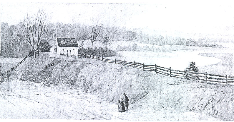
Illustration #2
For photograph of a water color by L. S. Cranston made in Williamsburg in 1850-60, see: Research Department.
Scene — "House at Capitol Landing" Original owned by W. H. C.
Illustration #3
Lots at Capitol Landing (York County Records, cards in Research Department files.)
| Lot #1 | (1718) | Trustees to John Davis; (1731) to Wm. Mayo |
| #2 | (1718) | Trustees to John Davis; (1731) to Wm. Mayo |
| #3 | (1762) | Wilson Miles Cary from Matthew Moody, ordinary keeper |
| #4 | (1721) | Trustees to Jonathan Drewit |
| #5 | (1717) | Trustees to Jonathan Drewit |
| #6 | (1717) | Trustees to Jonathan Drewit |
| #7 | (1714) | Feofees to Francis Sharp; (1726) to Samuel Cobbs (1726 |
| #8 | (1721) | Trustees to Jonathan Drewit |
| #9 | (1721) | Trustees to Jonathan Drewit |
| #10 | (1762) | Wilson Miles Cary from Matthew Moody |
| #11 | (1722) | Trustees to John Davis; (1731) to Wm. Mayo |
| #12 | (1722) | Trustees to John Davis; (1731) to Wm. Mayo |
| #13 | (1720) | Trustees to Lewis Holland (date?) to Samuel Cobbs |
| #14 | (1720) | Trustees to Lewis Holland (1726) to John Harmer |
| #15 | ||
| #16 | ||
| #17 | (1741) | Richard Booker to Benjamin Bryan |
| #18 | (1741) | Richard Booker to Benjamin Bryan |
| #19 | (1741) | Richard Booker to Benjamin Bryan |
| #20 | (1741) | Richard Booker to Benjamin Bryan |
| #21 | (1741) | Richard Booker to Benjamin Bryan one half lot |
| #22 | (1717) | Trustees to Giles Moody |
| #23 | (1717) | Trustees to Giles Moody |
| #24 | (1717) | Trustees to Giles Moody |
| #25 | Trustees to Giles Moody | |
| #26 | (1719) | Trustees to George Gilbert (1745) Chas. Rudder to Thos. Hornsby |
| #27 | (1719) | Trustees to George Gilbert (1720) to Graves Packs (1745) Rudder to Hornsby |
| #28 | (1719) | Trustees to George Gilbert (1745) Chas Rudder to Wm. Pride to Hornsby |
| #29 | (1719) | Trustees to George Gilbert (1745) " " Hornsby |
| #30 | (1717) | Trustees to Jonathan Drewit |
| #31 | (1717) | Trustees to Jonathan Drewit |
| #32 | (1723) | Trustees to Jonathan Drewit |
| #33 | (1723) | Trustees to Jonathan Drewit |
| #34 | (1741) | Richard Booker to Benjamin Bryan; (1719) ? John Blair from Trustees |
| #35 | (1741) | Richard Booker to Benjamin Bryan |
| #36 | (1720) | Trustees to Lewis Holland (1736) to John Kiadye |
| #37 | (1720) | Trustees to Lewis Holland (1736) to John Kiadye |
| #38 | (1720) | Trustees to Lewis Holland (1736) to John Kiadye |
| #39 | (1720) | Trustees to Lewis Holland (1736) to John Kiadye |
| #40 | ||
| #41 | (1719) | Trustees to John Blair ? * |
| #42 | (1719) | Trustees to John Blair ? * |
| #43 | (1718) | Trustees to Ambrose Cobbs; (1720) Trustee to Robt. Cobbs; (1725)? to John Blair * |
| #44 | (1718) | Trustees to Ambrose Cobbs; (1720) Trustee to Robt. Cobbs; (1725)? to John Blair * |
| #45 | ||
| #46 | ||
| #47 | ||
| #48 | ||
| #49 | ||
| #50 | ||
| #51 | ||
| #52 | ||
| Lot #53 | ||
| #54 | ||
| #55 | ||
| #56 | ||
| #57 | ||
| #58 | (1720) | Trustee to Thomas Jones |
| #59 | (1722) | Trustee to Thomas Jones |
| #60 | (1722) | Trustee to Thomas Jones |
| #61 | (1722) | Trustee to Thomas Jones |
| #62 | (1722) | Trustee to Thomas Jones |
| #63 | (1722) | Trustee to Thomas Jones |
| #64 | (1720) | Trustee to Lewis Holland; ( ) to Samuel Cobbs; (1736) to Jno Harmer |
| #65 | (1720) | Trustee to Lewis Holland |
| #66 | ||
| #67 | ||
| #68 | (1720) | Trustee to Lewis Holland; ( ) to Saml Cobbs; (1736) to Jno Harmer |
Trustees to John Holloway (1715) 53 square poles adj lot 32
* these lots probably were in Williamsburg on Duke of Gloucester Street as no one was in possession of them on these dates. See house history of these lots, Research Dept. In 1771 John Blair conveyed to George Chaplin Jr. 8 lots on the Capitol Landing Road.
VG April 22-29, 1737 (Parks):
Home of Wm. Mays of Goochland Co, 40' x 20' at Capitol Landing, Williamsburg, for sale.
YCR, O & W 17, p 210: August 16, 1731
Suit by Wm Mays vs James Davis, son of John Davis, lots 1, 2, 11 & 12 at Queen Mary's Port.
Illustration #4
| 1747 | Thomas Penman to Matthew Moody, Ordinary Keeper | Land 87 acres on Capitol Spring Branch |
| 1750 | Matthew Moody to Thomas Cobbs | 1 acre on road to Capitol Landing |
| 1761 | Matthew Moody to Matthew Hatton | 4 lots on east side of main street leading to Capitol Landing |
| 1761 | Benj. Bayley to Wm. Trebell | Lot on road to Capitol Landing |
| 1761 | Matthew Hatton, carpenter, to John Greenhow | 4 lots on west side street leading to Capitol Landing |
| 1762 | Matthew Moody to John Greenhow | 6 1/3 acres — four different areas, C. C. C. and B. the whole bounded by Gilmer occupied by Trebell, adj public goal and John Coke, John Bell |
| 1758 | Matthew Moody to Matthew Tuell | 1 lot bound on south by Tuell's purchased of said Moody, north by lot lately granted to John Bartley by said Moody |
| 1760 | Matthew Tuell, carpenter & joiner to Wm. Pearson, tanner | Lot #1 purchased by Tuell of Alexander Craig in 1758. Craig purchased of Christopher Ford who bought of Benj. Waller |
| 1760 | Jno. Ferguson to Wm. Pearson, tanner | 67 pounds, lots #4 & #5 purchased by Ferguson of Alexander Craig in 1758 |
| 1760 | Alexander Craig to Wm. Pearson | 300 pounds; lots #2 & #3 purchased by Craig of Christopher Ford in 1758 in bottom bounded by lands of a free school and Benj. Waller |
| 1762 | Thos. Craig to Wm. Phillips | 2 lots adj. lot of Wm. Trebell purchased by Craig of Matthew Moody |
| 1762 | Matthew Moody to Thos. Craig, tailor | 3 lots bounded north by Bell Craig Street, east by Moody's lots, west by Moody Street and 2 other lots on the north side of street bounded east by John Bell's lots, north by Alex. Finnie, west by Moody's street — 5 ½ lots in all |
| 1762 | Wm. Pearson, tanner, to Thos. Cobb, joiner | land 121 feet bounded by Capitol Landing Road to west; north 94 feet by Pasture ground of Pearson; east 91 feet bounded by said ground; and south 113 feet and bounded by Benj. Waller land |
| 1762 | Matthew Watts Hatton, carpenter & joiner to Alex. Finnie | 4 lots on east by Capitol Landing street, south by John Bell, blacksmith, north by John Coke's |
| 1763 | Benj. Waller to Wm. Pearson | Lot #6 leading from Queen Mary's Port part of larger tract bought by Waller of Mann Page |
| 2 | ||
| 1763 | Benj. Waller to Benj. Powell | 2 lots denoted in town plan as #19 & #43 |
| 1764 | John Bell, smith, to Frederick Bryan | 2 lots bounded south by Bell Craig Street north by Hatton's lots; east by road leading from city to Capitol Landing — formerly Matthew Moody's lots and sold to Bell in 1762 |
| 1765 | Wm. Pearson to Thos. Cobbs | Lot #6, 100 Pounds, on Queen Mary's Port Road. |
| 1765 | Alex. Finnie to John Blair | 210 pounds, 2 lots on main road to Capitol Landing whereon John Shepherd, harness maker now lives for 150 pounds; and 6 lots adj. the two on main road and the rest adj Coke's land |
| 1766 | Wm. Philips to Robt. and Lawrence Smith | 1 piece of land on street leading to the Capitol Landing |
| 1767 | Thos. Craig to Alex. Craig, Edward Charlton, Gabriel Maupin, and Blovet Pasteur | 5 lots on west of road leading from Capitol to Queen's Creek |
| 1768 | Thos. Cobbs, carpenter, Jno. Prentis, merchant, to Jno. Lewis, merchant | land east side of road leading to the Capitol Landing and adj. Tuell, and Jno. Bell |
| 1768 | Thos. Cobbs, carpenter, Jno Ferguson to Wm. Pearson, tanner, | 1 lot #6, on road leading from Queen Mary's Port |
| 1771 | Geo. Chaplin Jr., butcher, to Wm. Pearson, | 8 lots on road to Capitol Landing bounded by Benj. Powell, James Southall, Thos. Craig, and Frederick Bryan being lots conveyed to George Chaplin Jr. by John Blair. |
| 1772 | Benj. Waller to Elizabeth Carlos | lot #20 on street leading to Queen Mary's Port |
| 1772 | Thos. Powell, surgeon, to Wm. Prentis | 250 pounds, lot #30 on Page Street, adj. John Lamb which lot was conveyed to Thos. Powell by his mother, Lucy Powell, to whom the same was devised by her husband, Seymour Powell. |
| 1777 | Eliz. Carlos to Bartholomew Dandridge | 225 pounds — Lot #20 |
| 1777 | Benj. Powell to John Farquharsen | Land bound on east by Queens Street leading to Queen Mary's Port and adj William Pearson |
| 3. | ||
| 1778 | Jno. Lewis to Cornelious DeForrest | 1075 Pounds — land bounded on east by main road leading to the Capitol Landing; south by John Perrin, west by land of John Greenhow, and north by Matthew Tuell, being land whereon John Lewis formerly lived and purchased of Thos. Cobbs and John Prentis in 1768. |
| 1780 | Saml. Firth and Anthony Cooper to Hugh Moody and John Logan | ¾ acre whereon the shop of Matt Tuell, decd., stands, on main road leading to the Capitol Landing |
| 1782 | Benj. Powell to Zach. Rowland | £340, 2 lots on street leading to Queen Mary's Port, lots numbered, #19 & #43 purchased by Powell of Benj. Waller. |
| 1782 | John Logan to Hugh Moody | Lot on street leading to the Capitol Landing adj. John Shepherd's and Thos. Skinner. |
| 1783 | Benj. Waller to Benj. Carter Waller | 96 acres on east side of main road to Queen Mary's Port bounded by valley below Mattey's Schoolhouse to marsh on Queen's Creek lately in tenure of John Custis, decd. thence along the side of the marsh to the land laid out for Queen Mary's Port, thence along the said Port to the main road — which tract was sold Waller by Benj. Powell by deed 1769. |
| 1788 | Matthew Pearson to Serafina Formicola | 8 lots bounded north by Farguharson, west by Southall, south by Thos. Craig, and Frederick Bryan, and east by road leading to the Capitol Landing — which lots were purchased by Wm. Pearson of George Chaplin 1772 and which the said Matthew now holds by inheritance |
| 1789 | Wm. Hornsby to Saml. Crawley | Tract on marsh of Benj. Powell and adj Palace lands, road leading to Capitol Landing — 30 acres |
| 1790 | Henry W. Nicholson to Saml. Crawley and Richard Booker | Tract 30 acres on road leading to Capitol Landing with Queens Creek to north and Benjamin Powell's lands west. |
| 1797 | John Waller to Hunter Royle | 2 lots west side of street leading to Capitol Landing adj William Trebell and Frederick Bryan being same land purchased by John Waller of George Braxton who bought of William Phillips who purchased of Thomas Craig. |
Illustration #5
| 1687 | Jerom Ham to Edward Jones | 15 acres adjoining to 300 acres of Ham upon the Creek |
| 1694 | James Whaley to Daniel Parke | 100 acres known as Oyster Bank |
| 1695 | Wm. Chesley to Daniel Parke | Near head of Queen's Creek on which Philip Chesley lived — 450 acres |
| 1695 | James Whaley to Daniel Parke | 100 acres on North side of Queen's Creek adj. 100 acres sold by Whaley to Parke called Oyster Shell Bank formerly granted by patent to John Wilson and sold to James Goodwin |
| 1700 | Jno. Pell, heir of Otho Thorpe to James Whaley to Capt Page, Col Philip Ludwell, Benj. Harrison of Middle Plantation | 150 acres whereon Whaley lives, and 100 acres known as Queen Creek Quarter |
| 1706 | Geo. Brack to James Whaley (decd.) and Martha, his wife, | dwelling house now or late in tenure and occupation of Charles Chiswell, also lands 150 acres, also land called Queen Creek Quarter ca 100 acres, also land whereon school house now stands ca 50 acres |
| 1707 | Mary Whaley, widow of James Whaley, to John Page | land near Middle Plantation on branches of Queen's Creek ca 200 acres — a run divides this land from lands whereon a schoolhouse stands and plantation where James Whaley lately lived |
| 1711 | Mary Whaley to David Bray | Lands and plantation on west side of head of Queen's Creek, near above town of Williamsburg, purchased by Richard Thorp of John Dickison — bequeathed unto Otho Thorp, decd., and by several means came to Mary Whaley |
| 1714 | James Bates to James Morris, carpenter | land on north side Queen's Creek nearly opposite to the Capitol Landing which James Bates purchased of John Hall and wife, the only surviving sister and heir of Edward Davis — tract formerly Ashwell Batten's, grandfather of Edward Davis. |
| 1734 | John Randolph to Alexander Kerr | 100 acres on Queen's Creek above the Capitol Landing known as Hicks where David Bray died seized |
| 1737 | Mary Whaley to John Custis | 100 pounds value — plantation known as Whaley's Old Field, 100 acres bounded east by estate of Mann Page, south by Elizabeth Bray, west by Elizabeth Bray and John Custis, town land and marsh lying upon Queen's Creek — except Mattey's Schoolhouse containing one wooden dwelling house, kitchen, coach house, and school house |
| 2. | ||
| 1742 | Jno. Lidderdale, merchant, to Jno. Baskerville, bricklayer | plantation on both sides of road to Queen Mary's Port, bounded east next below Mattey's Schoolhouse to marsh on Queen's Creek now in tenure and occupation of John Custis, formerly granted to Mary Whaley, then on west side of main road along said port to land of John Custis — Also 100 acres adj Alexander Kerr now in the possession of Lidderdale — said land having been sold by John Custis and Daniel Parke Custis in 1737. Both parcels of land descended to Elizabeth Lidderdale, daughter and heir of William Robertson |
| 1743 | Jno. Grame, exec. Alex. Kerr, to Thos. Cobbs | 100 acres upon Queen's Creek above the Capitol Landing known as Hicks purchased of Sir John Randolph, Knight, decd |
| 1752 | Alex. Finnie to Jno. Chiswell and Geo. Gilmer | 20 acres near Capitol Spring Branch purchased of Andrew Anderson in 1747 |
| 1753 | Wm. Clark to Benj. Bryan | Land on Queen's Creek via Robert Clark 50 acres |
| 1753 | Geo. Kendall to Daniel Parke Custis | plantation 200 acres |
| 1754 | Wm. Stanhope, to Benj. Waller | 72 acres on south side of Queen's Creek via John Hubbard, father of Mary Stanhope. |
| 1754 | Lewis Davis, to Daniel Parke Custis | 176 acres — 189 pounds 4 shillings — north side Queen's Creek via father of Lewis Davis |
| 1754 | Ambrose Cobbs to Lawson Burfoot | 100 acres near Col. Custis's and Keith |
| 1754 | Matthew Moody, Inn Holder, to Matthew Tewell | ½ acre bounded on south by acre granted lately unto Thomas Cobbs, and on north by land of Moody |
| 1758 | Matthew Moody, innholder to John Bartle | ½ acre bound on east by the street, on the south by Matthew Tewell, on west and north by land of Moody |
| 1758 | Moody to Bartle | ½ acre bounded on east by the street, south by John Bartle, west and north by Moody |
| 1758 | Mary Cobbs, widow, to Peter Powell, chairmaker | 120 acres on south side of Queen's Creek, via Thomas Cobbs, late husband. |
| 1759 | Matthew Moody to Benj. Bayley, merchant | 1 lot bounded by John Bartle on south, east by street or road to Capitol Landing, on north by Edward Bowcock and west by Moody |
| 3. | ||
| 1760 | Matthew Moody to Francis Fauquier | 35 acres bounded by Fauquier's land, Raleigh Tavern, John Coke's line — land purchased by Moody of Thomas Penman in 1747 |
| 1773 | John Ferguson to John Tazewell | 300 pounds — tract of 100 acres bounded by Queen's Creek, Governor's Land, Benjamin Powell, Peter Powell and Col. Custis — formerly sold to Thomas Cobbs from Alex. Kerr |
| 1774 | Peter Powell to Benj Powell (chairmaker) | Land on southside of Queen's Creek 120 acres being same land conveyed to Benj Powell by James Anderson |
| 1774 | James Anderson, blacksmith to Benj. Powell | 232 pounds tract 120 acres south side Queen's Creek — which tract devised to Mary Cobbs by Thomas Cobbs and by Mary Cobbs sold to Peter Powell who conveyed to James Anderson |
| 1780 | James Carter to James Hill | 477 acres partly on York River between Robert Wormeley Carter and the lands of John Travis (situated on the mouth of Queen's Creek) and running between those lands adjoining Porto Bello the late property of John Earl of Dunmore and adjoining Bryans lands. Consideration: £2385 |
| 1803 | Armistead Burwell to Nathaniel C. Walker | tract on Queen's Creek whereon Benj. Powell, decd., formerly resided, (Burwell's wife a Powell) |
| 1805 | John Bryan to Benj Carter Waller | 40 aces on north by road leading from Porto Bello, east by Francis Bright's, south by Charles Orrell and west by Waller's lands — said tract conveyed being part of land devised to John Bryan by Frederick Bryan. |
| 1783 | Carter Braxton to Benj. Carter Waller | piece of marsh — 17 acres bounded on south by Benjamin Waller, east by marsh of Waller, north by Queen's Creek, "west by road leading immediately to the landing commonly known and called by the name of Queen Mary's Port where vessels generally lye ." |